Friday, April 26, 2013


4/26/2013, Friday: Staying at Carson Nugget Casino, free, in Carson City, NV today. The road to Yosemite is still closed, so we kept on going north. The area between Crowley Lake and Carson City goes through Humboldt Toiyabe National Forest.  Lots of trees and some snow on the mountains yet. Lots of rocky areas and some desert. Lakes, rivers, irrigation and cattle. We passed an area that had a forest fire. Curt is pleased with how the RV handles the hills. Hwy 395 takes us through Nevada at this area and then north will be back in to California.


We spent the last three days at Crowley Lake Recreation Area near Crowley Lake, CA. I’m not really sure what the address was as there are small towns and lakes all over. Open fishing starts this weekend here. It’s a BLM campground with a picnic table, grill and lantern pole. There are water spigots every so often and a dump (for $5). We spent time driving around the hills and lakes and Curt did some metal detecting.  

There’s a lake called Mono Lake that is an ancient saline lake. It has no fish; instead it is home to trillions of brine shrimp and alkali flies. In 1941 the Los Angeles Department of Water & Power began excessive water diversions from Mono Basin streams. Mono Lake dropped 45 vertical feet, lost half its volume and doubled in salinity. A committee was formed in 1978 to try to help save the lake. In 1979 the committee took the City of Los Angeles to court. In 1994 the California Water Resources Control Board ordered to let Mono Lake rise to a healthy 6392 feet above sea level – 20 feet above its historic low. Along the lakeshore scenic limestone formations known as tofu towers rise from the water’s surface. Millions of migratory birds visit the lake each year. Mono Lake also has craters nearby. They are volcanoes that have a plug in it. We hiked up to see one of them Panum Crater. Not sure what we were thinking it would be like, but not what it was.  We could have done more hiking but Curt’s knee was bothering him and my back bothering me; what a team we are.


 We drove around June Lake and to Convict Lake. Mammoth Lakes is a town that has Rainbow Falls and multiple small lakes. Also Devils Postpile National Monument is there and Inyo craters, so we thought we’d give it a try. Well, needless to say, we got to see snow and the roads were closed to all the places I wanted to see. Yup, this is getting frustrating.


Monday we stayed at Tri-County Fairgrounds in Bishop, CA. They had full hookups. We were the only “current” RV in the fairgrounds. There were a few others there and campers, but I don’t think they were actually living in them. There were also some boats stored there. They must board horses too, a few corrals. This picture is for Calissa!


We also stopped at the visitor’s center in Bishop and picked up lots of California information and got a geocache. We haven’t gotten to a visitor’s center or information center since we’ve gotten into California so it was good to see this. Too bad we didn’t have it before I found out we couldn’t in to the National Parks.

Sunday night we stayed at Boulder Creek RV Resort, Lone Pine, CA.  We found out that we can’t get in to the  national parks like we had thought. We’re on the east side of the mountains instead of the west. Good mapping skills. I know we were looking for roads that would be easier for the RV (California has bus and RV maps online), but never paid attention that there weren’t east-west roads through the parks. There is through Yosemite, but so far that road is closed; so, I’ll keep on eye on that. We’re also noticing that a lot of the campgrounds don’t open until middle of May or June either. We talked about going to Death Valley National Park from here; it’s over 100 miles one-way and today would be 103 degrees. This is not sounding promising. 

Saturday, April 20, 2013


4/20/2013, Saturday: We’re at Barstow, California today. Another new state, new rules. There’s a BLM campground nearby, but it sounds like it is about 5 miles of dirt road to get there, and we’re not even sure what the campground area looks like. We’re going to try Walmart for the night.


Yesterday we got to Las Vegas, Kings Row RV Park. It’s only $16 with full hookups, but it’s a really old park. It’s near an airport so there’s airplanes flying overhead constantly. We checked in and then took the Jeep to the Las Vegas Strip. It took a while to figure out where we can park free at the casinos, but found a parking garage at Treasure Island Casino. From there we walked the strip south and back north. Curt didn’t want to stop in Las Vegas. He doesn’t like driving in big cities and had no desire to see Vegas itself. I owe him big time. We walked for hours, up and down steps, through buildings. I found out looking at the map today that we did miss a couple casinos, including seeing the Sphinx. I’m glad we stopped, but I’m sure we won’t be back. Going in the evening probably would be more glamorous-looking with all the lights and all, but we were so tired we came back home. There were so many people; all nationalities, all languages. We aren’t used to people being so rude and so forward, and the sleaziness of the area. Men and women handing out cards for “ladies”.  People don’t care if they run into you or not. Oh well. I did get 4 “smashed” pennies out of it.


 At the Flamingo inside Habitat

People dressed up as characters, then charged for pictures with them


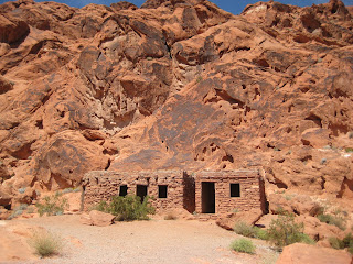
Thursday we were at Atlatl Rock Campground, Valley of Fire State Park, in Nevada. Full of hills and strange rock formations, from reds to yellows to whites. We got here around noon and found a camping spot and then went to the visitor center for a map of the park and trails. We went on 3 trails, totaling 3 miles, and we were tired at the end simply because the trails are almost all sand. Hiking in beach sand with hiking boots on is not fun. One of the trails was some rock climbing down, and if we hadn’t seen people on it, we wouldn’t have known for sure if it was even the trail. They’re not marked well at all, even if there are signs at the beginning to stay on the trail. It was fun though, with a high of 69 degrees. Not very good cell phone service in the whole park, just a few areas where you get a few bars. It’s $20 for no services or $30 for water and electric. We went for the water and electric. It costs about $8/day to run the generator so we opted for the electricity and can recharge batteries.


Petroglyphs

 Cabin built by the CCC

Atatl Campground

From Monday through Wednesday we were at Boulder Beach Campground in the Lake Meade Recreation Area near Hoover Dam. We toured the dam in the morning and then found the campground after that. It is a National Park Service Campground, no amenities, for $10. We did have a little view of Lake Mead. We decided to stay a couple days because of the wind ~ gusts up to 30 again.

Lake Mead

Hoover Dam is huge. I was totally impressed; Curt no so much. He’s seen so much on TV about it, I think he expected more. It’s not real wide, but really deep.  Vehicles have to go through a checkpoint before you get there; campers had to be inspected. We had to get out and Curt had to open our basement compartments. Another guy asked to go inside so I went with him. He just walked to the end, looking around, peeked into the bathroom (door was shut) and came back out. Not what we expected for an inspection. From there you go on to a parking lot if you want to walk on the bridge over the dam. So we go from Nevada to Arizona, back to Nevada again. It was really windy on the bridge. From there you take some winding roads down to the actual dam area. Being in an RV we had to park on the Arizona side, up the hill a ways and walk down. We opted not to take any of the tours (from $11-$30), or even go in the visitor center which was $8 each. We’ve seen documentaries on Hoover Dam and expect that’s what they would have been about. They did have a gift shop though where I got a smashed penny. Lots of people all over; again all nationalities.


Saturday, April 13, 2013


04/13/2013, Saturday:  One year ago today we left Dickinson and left our “old life” behind. It doesn’t seem like it’s been a whole year, but as I see my granddaughters on FaceTime or Google, I see they’ve both grown up a lot.  Who would’ve thought a year ago we would have driven thousands of miles and gone through 24 states. We’ve seen the ocean on the east coast, beautiful mountains and desert. We’ve had rain from 2 hurricanes, snow from a blizzard and was even near 2 earthquakes (small enough that we didn’t know about it). We’ve been really lucky as far as the weather we’ve been in and having no accidents. We’ve been able to keep in touch with family with computer and cell phones. We’ve been in some nice campgrounds and ones we wouldn’t go back to. We’ve been overnight at Walmarts that were very safe and others that we left. We’ve learned a lot over this year, but there’s still so much more about this journey to learn and enjoy. We’ve learned to drive less and enjoy things more! 

To another safe year on the road...

Friday, April 12, 2013


04/12/13, Friday: This past week we spent a night at Cattail CoveState Park south of Lake Havasu City, AZ. We needed to dump tanks and fill water and recharge batteries. We didn’t make a reservation, they charge an extra $5 for that. We went into town on Tuesday and picked up our mail (taxes finally done) and stopped at the Park on the way back. It’s only a mile from the BLM spot we were on. They have water/electric sites for $26 and a dump station. I asked if they had a 50 amp site (most are 30 amp)  and large enough for 40 ft. She said we could take the host’s empty site (they just left) for $30. It has water/electric/sewer. We decided to do that and then I can wash clothes and not go to a laundromat in town, or save it for another week or two. So we went back to get the motorhome and move over here.  I spent the day washing clothes and baking cookies and banana bread and brownies.  The next day we had to be out by noon. Curt changed water filters and cleaned the water softener. Arizona water is hard.  He tried washing the motorhome and Jeep but the water left spots so he had to clean them off.

From there we moved to another BLM area north of Lake Havasu.  When we were in town we stopped at the BLM area office and got a map with some areas; but it doesn’t give the actual road to take off of the highway. You basically have to watch off the road to see if there’s campers parked along the side or if there’s BLM signs. This is a small area but there are probably a dozen campers there; motorhomes, fifth-wheelers, mini- homes, pickup toppers. You’re only supposed to be on BLM land for 14 days, but I don’t think the areas are checked very often. Some of these looked like they had been there a while.  We had some real windy days at the last BLM site we were at, and then another day here. Some of the campers came off of the road for the day. We went for a hike the next morning and saw that one of the campers was from North Dakota – small world.

From there we went to Kingman, AZ Walmart. They said we can stay there overnight, but if the police tell us to move, we have to move. Must be a town ordinance for no overnight camping. Parker was the same way, but they told us we probably should just go to the casino and we could stay there free (which we did).  Kingman Walmart had campers come and go throughout the afternoon. About 10 of us stayed the night. I don’t think the police have a problem with campers there as long as you’re on the outskirts of the lot and traffic can still come and go. There’s 2 motorhomes that look like they’ve been there a while. 

Today we took a tourist day with the Jeep and went on Historic Route 66 to Oatman and then decided to do a loop back to Kingman by going to Bullhead City and then back. We didn’t want to take the motorhome because the road to Oatman is narrow and lots of twists and turns through the hills. This is the most scenic part of the whole loop. It’s constant twists and turns and hills and rocks. After Oatman it turns into a desert valley and washes and rolling hills. There’s also gold mine sites.  Oatman is a town of 134 people and “wild” burros. I  say “wild” because they are not owned and live in the hills, but some come to town to be fed by the tourists and they’re very tame. They were left by the miners when they left. The town lives on the tourists. There are little shops selling Route 66 items and burro items, leather items (made in North Dakota), restaurants and the original Oatman Hotel from the 1900’s. In the restaurant and bar in the hotel there are dollar bills that are signed and dated from people and stapled on the walls. There are thousands of dollars in there. They have a gunfight at noon so we waited around to see that. It was pretty short. From Oatman we went on to Bullhead City, which is another snowbird town. It is across the river from Laughlin, Nevada, which is a “mini” Las Vegas. You can see the casinos across the river. We went through an Indian reservation and an area which was irrigated and farmed. It was nice to see the green alfalfa and grass; also “normal” trees. Near Kingman on the way back we passed an area that had 2 motorhomes off the side of the road, which we suspected was BLM area to park. So after getting back to Walmart, we picked up some groceries, hooked up the Jeep and decided to go to the BLM site for the weekend and then head to the Lake Mead/Hoover Dam area on Monday. The only problem is that in going to that BLM site, we had to go another 2 miles or so past it since there is a concrete divider in the highway all the way up and down the 6% grade of the hill, and then turn around and come back. We found out it’s the Cerbat Foothills Recreation Area, Monolith Garden Trailhead. We can stay here 14 days if wanted.

Curt did some metal detecting while I did some catching up on the computer. He didn’t find much of anything, but he likes his new headphones (thanks kids!) When we were at the BLM office in Lake Havasu they said that there was some meteor and gold findings on the BLM sites yet. I forgot to mention, at the BLM site we were at south of Lake Havasu, there was a van that was brought in and shot up. There was a lot of traffic coming and going at that place. A lot of 4-wheelers were driving around. One day we saw a pickup pulling a trailer with a white van on it. We thought someone was having work done on it or something like that, didn’t pay any attention to it. There is a site behind some hills that people were doing shooting before, so we didn’t pay any attention when we heard shooting again. Some of them were pretty loud. Curt thought about going there to see what they were using but decided against it. Curt said he saw the pickup and trailer leaving later without the van, but again, didn’t really think anything of it. The next day we drove around the area to see if there were other places to park and saw the shooting site and the van was shot and blown to pieces. We took pictures and this was another reason we stopped at the BLM office, to show them the pictures. There isn’t much they can do. They only have 2 rangers in the area, one for the water and one for the land. They can tell the sheriff’s office and maybe they can get the serial number and track it. Evidently they don’t clean up the area because we found a ravine that had old shingles and appliances that people dumped. He said sometimes the Jeep clubs will clean up. Budget cuts…


We hiked around 3 miles, followed the ATV trails up and down the hills.

 The "wild" burros

Gunfight


Destruction on the BLM land


 Historic Route 66 - I can't imagine wagons or old cars going through these hills.

Saturday, April 6, 2013


4/06/2013, Saturday:  Mind over matter. That’s what Curt tells me. It’s been in the lower 90’s a few days this week. We’re boondocking and that means not using the air conditioning. He says just to tell myself it’s not that warm and quit looking at the thermometer.  I have to hide the thermometer and then I won’t know how hot it actually is and I’ll feel better?  Yesterday I was dumb enough to put on my sundress and go outside and get sunburned. It’s hot enough for that.

We’re near mm 166 between Parker and Lake Havasu City, AZ. There’s an area for free  BLM boondocking here, I believe called Standard Wash, or The Steps, (not sure which) and than again closer to Lake Havasu City another couple of areas. They’re right off of the highway. This one has some hills around it and we can see the Colorado River and California across the highway. (The Colorado River is the state border.) North from Parker it’s gotten much more hilly, especially on the California side.  Haven’t seen a snake here, thank goodness. There are lizards and in my logic that means there are no snakes because the lizards would have been eaten.  We’re very watchful though, logic or not. This area has a lot of 4-wheelers. The other areas we were at did too, but the areas were so big that you really didn’t pay attention unless it was really windy and the dust came over. This area is small and you notice all traffic.  We’re near Cattail Cove State Park, which we’ll go too when we need to dump tanks and fill water. We do get cell service here, but no TV at all. Last night we were able to watch Survivor on-line. Other than being able to catch local news and weather, I really don’t miss it. And after all, the weather is “mind over matter”, right?

We went into Lake Havasu City Wednesday, toured the London Bridge and drove around. Of course we had to find Lowe’s and Home Depot, but they didn’t have the steel Curt needed. He wants to build another battery box area so we can add more batteries for more solar. Lake Havasu City is very much a tourist town, depending on the weather and their water sports. All along Highway 95 are businesses for boating, RV, ATV’s, etc. The houses along the highway are very impressive. Either Lake Havasu City is a wealthy town, or the old houses are hidden away from the main highway. Curt noticed that most of the houses have their air conditioners on the roof; that’s something we haven’t seen before. At the London Bridge area is also the visitor’s center and little tourist shops. There are tours by boat, helicopter, air balloons, airplanes. Some go all the way to the Grand Canyon. They have golf courses, parks, hiking, gold club and even a boomerang club.

London Bridge history: In 1968 Robert P. McCulloch (of McCulloch Oil) bought the London Bridge for $2,460,000. (It was up for bids.)  Each block was numbered before the bridge was taken apart, and then shipped overseas through the Panama Canal to California and trucked to Arizona. It was reconstructed at Lake Havasu City, AZ. (McCulloch was also the founder of Lake Havasu City.) It was built on land, which was then dug out to connect to the lake. The total cost of the bridge was $5.1 million. The entrance gate was part of Witley Court in Worcester, England. The vintage lamps on the London Bridge are made from the melted down cannons of Napoleon Bonaparte’s army.  The bridge is rumored to be haunted. For years visitors have sighted the figures of a British police bobby and a woman in black.

Lake Havasu has 22 lighthouses. Each one is an actual navigational beacon for boaters on Lake Havasu and meets all U.S. Coast Guard requirements. All but one lighthouse is 1/3 scale replicas of actual U.S. lighthouses. Eleven are accessible by land. We saw 2 of them; Vermillion, OH and Split Rock, MN replicas.

We put up our hummingbird feeder again, simply because when we got here, before we even shut off the engine, we had a hummingbird flying around our windshield. Think they’re used to being fed?  It’s not near as busy as the other places we’ve been, and these seem smaller. 

I’ve found a good use for magnetic advertising; you know, the ones you get that have calendars or advertising on them like a business card?  They’re probably about 2 x 4, 4 x 4. I peel off the advertising and cut up some pictures of our granddaughters from their calendar and tape them on the magnets and put them on my fridge. I could have gotten lots of the magnets at the RV tent show in Quartzsite in January if I would have thought of that then.